Constraining groundwater flow, residence times, inter-aquifer mixing, and aquifer properties using environmental isotopes in the southeast murray basin, australia

Contents lists available at
Applied Geochemistry
Constraining groundwater flow, residence times, inter-aquifer mixing,and aquifer properties using environmental isotopes in the southeast Murray Basin,Australia
Ian Cartwright Tamie R. Weaver , Dioni I. Cendón L. Keith Fifield Sarah O. Tweed , Ben Petrides ,Ian Swane
a School of Geosciences, Monash University, Clayton, Vic. 3800, Australiab National Centre for Groundwater Research and Training, Flinders University, Adelaide, SA 5001, Australiac URS Australia Pty Ltd., 6/1 Southbank Boulevard, Southbank, Vic. 3006, Australiad Australian Nuclear Science and Technology Organisation, Kirrawee DC, NSW 2232, Australiae Department of Nuclear Physics, Research School of Physical Sciences and Engineering, Australian National University, ACT 0200, Australiaf School of Earth and Environmental Sciences, James Cook University, Cairns, Qld 4870, Australiag Coffey Environments Pty Ltd., Abbotsford, Vic. 3067, Australiah Terrenus Pty Ltd., 12 Granville Street, Wilston, QLD 4051, Australia
Environmental isotopes (particularly d18O, d2H, and d13C values, 87Sr/86Sr ratios, and a14C) constrain geo-
Available online 22 February 2012
chemical processes, recharge distribution and rates, and inter-aquifer mixing in the Riverine Province ofthe southern Murray Basin. Due to methanogenesis and the variable d13C values of matrix calcite, d13Cvalues are highly variable and it is difficult to correct 14C ages using d13C values alone. In catchmentswhere d13C values, 87Sr/86Sr ratios, and major ion geochemistry yield similar a14C corrections, �15% ofthe C is derived from the aquifer matrix in the silicate-dominated aquifers, and this value may be usedto correct ages in other catchments. Most groundwater has a14C above background (�2 pMC) implyingthat residence times are <30 ka. Catchments containing saline groundwater generally record older 14Cages compared to catchments that contain lower salinity groundwater, which is consistent with evapo-transpiration being the major hydrogeochemical process. However, some low salinity groundwater in thewest of the Riverine Province has residence times of >30 ka probably resulting from episodic rechargeduring infrequent high rainfall episodes. Mixing between shallower and deeper groundwater results in14C ages being poorly correlated with distance from the basin margins in many catchments; however,groundwater flow in palaeovalleys where the deeper Calivil–Renmark Formation is coarser grainedand has high hydraulic conductivities is considerably more simple with little inter-aquifer mixing.
Despite the range of ages, d18O and d2H values of groundwater in the Riverine Province do not preservea record of changing climate; this is probably due to the absence of extreme climatic variations, such asglaciations, and the fact that the area is not significantly impacted by monsoonal systems.
Ó 2012 Elsevier Ltd. All rights reserved.
(e.g., temperature or altitude), or groundwater mixing (e.g.,
Environmental stable and radiogenic isotopes, especially d18O,
d2H, d13C and d34S values, 87Sr/86Sr ratios, and 14C and 3H activities
capacity to date groundwater that is up to 30 ka old, and due to
are invaluable tracers of regional-scale hydrogeological processes.
the ubiquitous presence of dissolved inorganic C (DIC) in ground-
Oxygen and hydrogen isotopes are the only true tracers of the
water, 14C is the most widely used radiogenic dating technique
water molecule and since all processes in the hydrological cycle
in regional aquifers (e.g.,
fractionate 18O/16O and 2H/1H ratios, d18O and d2H values may be
used to determine the extent of evaporation, recharge conditions
) and is invaluable in constraining the timescales ofgroundwater flow and recharge. Stable C and S isotopes trace thesources of dissolved inorganic and organic C and SO4 in groundwa-
⇑ Corresponding author at: School of Geosciences, Monash University, Clayton,
Vic. 3800, Australia. Tel.: +61 03 9905 4903; fax: +61 03 9905 4887.
and constrain processes such as bacteriological
E-mail address: (I. Cartwright).
0883-2927/$ - see front matter Ó 2012 Elsevier Ltd. All rights reserved.
doi:
I. Cartwright et al. / Applied Geochemistry 27 (2012) 1698–1709
reduction and methanogenesis (e.g.,
specific regions or concentrated on individual isotopic tracers.
87Sr is produced by the de-
The application of geochemical tracers to the adjacent Mallee–
cay of 87Rb with a half-life of 48.8 Ga. As Rb substitutes for K and to
Limestone Province a) is discussed by
a lesser extent Na in minerals, the 87Sr/86Sr ratio of a mineral is
governed by its initial 87Sr/86Sr ratio, its Rb/Sr ratio, and its age
. A significant part of rural SE Australia depends
on groundwater from the Murray Basin for agricultural, industrial,
). Strontium derived from K-rich minerals such as biotite
and, increasingly, domestic water supply. This demand will in-
and K-feldspar has high 87Sr/86Sr ratios while Sr derived from Ca-
crease as population grows, and ongoing development of this re-
rich minerals such as calcite or gypsum has low 87Sr/86Sr ratios.
gion relies on the long-term sustainable use of groundwater.
Thus Sr isotopes are important tracers of water–rock interaction
While this review concentrates on the long-term regional hydroge-
and mixing between groundwater from aquifers of contrasting
ology, it is also recognised that the salinisation of groundwater,
mineralogy. Unlike C, O, H or S isotopes, mineral precipitation
soils, and rivers due to rising water tables following land clearing
and dissolution does not fractionate 87Sr/86Sr ratios making Sr iso-
(e.g., is an important environmental issue.
topes reasonably straightforward to interpret.
When coupled with major ion geochemistry and physical
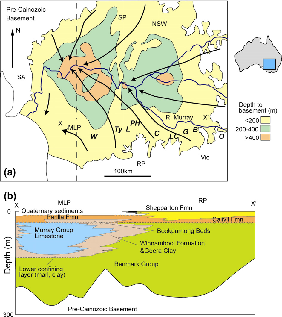
1.1. Murray Basin hydrogeology
hydrogeology, environmental isotopes constrain groundwater res-idence times, distribution and rates of groundwater recharge,
The Murray Basin (occupies �300,000 km2 of SE Austra-
water–rock interaction, and groundwater flow paths and are thus
lia and contains late Palaeocene to Recent sediments that overlie
fundamental to understanding hydrogeological systems and man-
Proterozoic to Mesozoic basement (
aging groundwater resources. Constraining recharge rates is re-
quired to assess the sustainability of groundwater use while
The basin is up to 600 m deep and comprises three
delineating recharge areas is required to determine potential
sub-basins or provinces (Riverine, Scotia, and Mallee–Limestone:
threats to groundwater from near-surface contamination. Deter-
a) that are separated by basement ridges. Except for a small
mining whether there is a climate control on recharge or if landuse
region in the SW that discharges to the Southern Ocean, the Mur-
changes have altered recharge rates is also important in under-
ray Basin is closed and groundwater discharges to salt lakes and
standing the long-term and future behaviour of aquifer systems.
rivers near the basin centre. The Murray–Darling river system is
Aquifers in northern Europe, Canada, northern China and Africa
the only major surface water feature draining the basin.
contain groundwater with distinctive d18O and d2H values that
The Riverine Province underlies the Riverine Plain of Victoria
were recharged under colder or wetter conditions than present
and New South Wales (There are three main strati-
graphic units in the eastern Riverine Province
b). The lowermost Renmark Group consists of Palaeocene to
late Miocene fluvial silts, sands, gravels, and clays that form a con-
indicating that recharge rates have
fined aquifer system. Overlying the Renmark Formation are the Pli-
varied on timescales of thousands of years. In southern Australia,
ocene sands of the Calivil Formation. In most of the Riverine
land clearing over the last 200 a following European settlement
Province, the Calivil Formation is in hydraulic continuity with the
has increased recharge
underlying Renmark Formation and these formations commonly
Thus modern recharge rates
form a single aquifer ). The Cal-
measured from bore hydrograph fluctuations or lysimeters may
ivil–Renmark Formation is thickest in ancestral drainage channels
not indicate the long-term behaviour. Documenting inter-aquifer
(‘‘deep leads'') of present day rivers (e.g., the Murray, Campaspe,
flow is also important. If groundwater flow is largely parallel to
Lodden, Avoca, Ovens, and Goulburn Rivers) that were incised after
stratigraphy, deeper groundwater may be protected from near sur-
the Middle Miocene marine regression and subsequently filled
face contamination; likewise, shallow groundwater and connected
with sediments (). Groundwater in these deep
surface water systems may be isolated from the impacts of pump-
leads flows northwards and feeds into the Murray deep lead where
ing of deeper aquifers. By contrast, significant inter-aquifer flow
groundwater flow is eastwards (Lateral hydraulic
may compromise both the quality and quantity of surface water
conductivities of the Calivil–Renmark sediments within the deep
and groundwater. Groundwater flow parallel to the main strati-
leads based on pumping or slug tests are 40–200 m/day (e.g.,
graphic units is reasonably straightforward to constrain using
hydraulic conductivities in the areas be-
hydraulic heads and hydraulic conductivities. However, because
tween the deep leads are lower
vertical hydraulic conductivities are less commonly measured
). The Calivil and Renmark For-
groundwater flow between, and vertically within, formations is
mations do not crop out and this aquifer is recharged by downward
more difficult to determine using physical hydrogeology (e.g.,
flow through the overlying units.
and relies on the application of geochemical
The uppermost Shepparton Formation comprises fluvio-lacus-
trine clays, sands and silts that are laterally discontinuous resulting
This paper reviews the contribution of environmental isotopes
in a highly heterogeneous aquifer system.
to understanding the regional hydrogeology of the Riverine Prov-
estimated that lateral hydraulic conductivities are 30 m/
ince of the SE Murray Basin, Australia. In particular, it assesses:
day for the coarser units of the Shepparton Formation and substan-
patterns and rates of recharge; whether the groundwater preserves
tially less in the fine-grained units; vertical hydraulic conductivi-
a record of climate change; groundwater flow paths; and the de-
ties are 10�5 to 10�1 m/day
gree of inter-aquifer mixing. There have been few attempts to inte-
). The heterogeneous
grate the environmental isotope data from the SE Murray Basin
nature of the Shepparton Formation may inhibit lateral flow, pro-
and previous studies (
moting downward leakage into the underlying Calivil–Renmark
Formation (In the western Riverine Prov-
ince, the Loxton–Parilla Sands comprises a sequence of marine
sands and silts that underlies the Shepparton Formation. Locally
) have largely discussed processes in
in this region, the Shepparton Formation is absent and the
I. Cartwright et al. / Applied Geochemistry 27 (2012) 1698–1709
Fig. 1. (a) Map of the Murray Basin (after ) showing depth to basement and groundwater flow paths. MLP = Mallee–Limestone Province, RP = RiverineProvince, SP = Scotia Province. Catchments (west–east) are: W = Wimmera, Ty = Tyrrell, L = Loddon, PH = Pyramid Hill, C = Campaspe, G = Goulburn, B = Benalla, O = Ovens. (b)Stratigraphic cross-section across the Mallee–Limestone and Riverine Provinces at approximately X–X0 (after showing major units in the MurrayBasin.
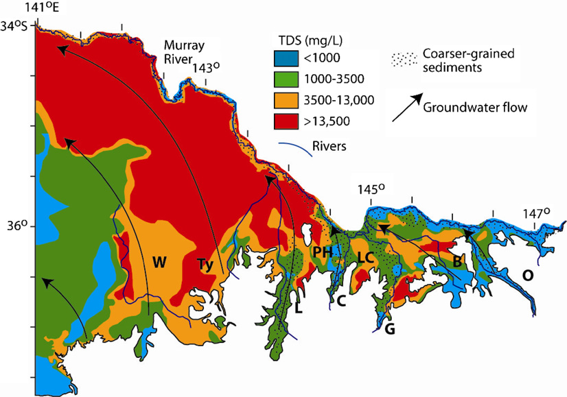
Fig. 2. Variation in groundwater TDS in the shallowest aquifers of the Riverine Province of Victoria (data from Victorian State Government Groundwater Beneficial Use Maps:). The TDS distributions represent broad averages and many local variations exist.
Catchments are as for . Dotted area denotes coarser-grained sediments in the deep leads (
I. Cartwright et al. / Applied Geochemistry 27 (2012) 1698–1709
Loxton–Parilla Sands is the surficial unit. In the far west of the Riv-
2. Sampling and analytical techniques
erine Province, the Loxton–Parilla Sands is underlain by the MurrayGroup, which comprises up to 130 m of marine and marginal mar-
Sampling and analytical techniques are discussed in detail in
ine limestone with calcareous sands, marls and silts
the original studies. In summary, groundwater was from monitor-
). The Ettrick Formation, Geera Clay, Bookpur-
ing bores that are maintained by the Department of Sustainability
nong Beds, and Winnambool Formation envelope the Murray
Group; these units are collectively referred to as Mid Tertiary Aqui-
that have screen lengths of 1–25 m and
tard units ), although hydraulic conductiv-
which sample only one lithological unit. The pH, EC, alkalinity,
ities are locally sufficiently high to allow flow across these units
dissolved CO2 and dissolved O2 were measured in the field using
calibrated metres or titration. Cations were determined using
Only the Geera Clay, which
ICP-AES on filtered and acidified samples. Anions were deter-
comprises up to 75 m of massive clays with minor sand and silt
mined on filtered unacidified samples using ion chromatography.
layers is an effective aquitard.
Stable isotope ratios were measured using gas source mass
The shallowest formations of the Riverine Province are uncon-
spectrometers. The 87Sr/86Sr ratios were determined by thermal
fined and recharge of groundwater occurs across broad areas (
ionisation mass spectrometry and 14C activities (a14C) were
measured using AMS techniques.
Aside from direct recharge,the Murray River and some of its tributaries recharge the shallowaquifer systems, especially at high river stages
3. Sr and C isotopes
Additionally, ex-cept in the west of the province, there are few aquitards
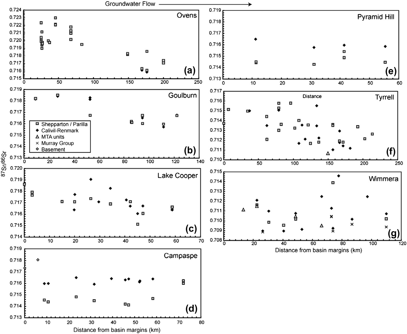
The 87Sr/86Sr ratios of groundwater in the SE Riverine Province of
potentially allowing widespread inter-aquifer flow to occur (
the Murray Basin, Australia are between 0.709 and 0.723
), and are generally higher than the 87Sr/86Sr ratio of rainfall
in southern Australia (�0.713:
The Riverine Province comprises several catchments
As Sr/Cl ratios are also higher than those of the
The Ovens, Goulburn, Campaspe, and Loddon catchments are
typical deep lead systems that contain lower salinity groundwater
there must be additional sources of Sr apart from rainfall containing
(total dissolved solids, TDS, typically 500–3500 mg/L: ), while
marine aerosols, such as silicate and carbonate weathering in the
the Benalla, Lake Cooper, Pyramid Hill, and Wimmera regions out-
unsaturated zone and/or mineral reactions in the saturated zone
side the deep leads generally contain more saline groundwater
of the aquifers. The bulk silicate fraction of the Renmark and Shep-
(TDS locally up to 100,000 mg/L and commonly >20,000 mg/L). An-
parton aquifers in the Riverine Province has 87Sr/86Sr ratios of
nual rainfall in the area depicted in varies from up to
0.718–0.931 while calcite in these aquifers has 87Sr/86Sr ratios of
2000 mm in the SE of the region to �400 mm in the NW; most of
the region has 400–600 mm annual rainfall (
The silicate fractions with
Rainfall occurs dominantly in the austral winter
the highest 87Sr/86Sr ratios are from the Ovens Valley and reflect
months (July–September) and for much of the year potential
the high degree of immature sediment derived from Palaeozoic
evapotranspiration rates exceed rainfall
metasediments and granites in this region. The relatively high
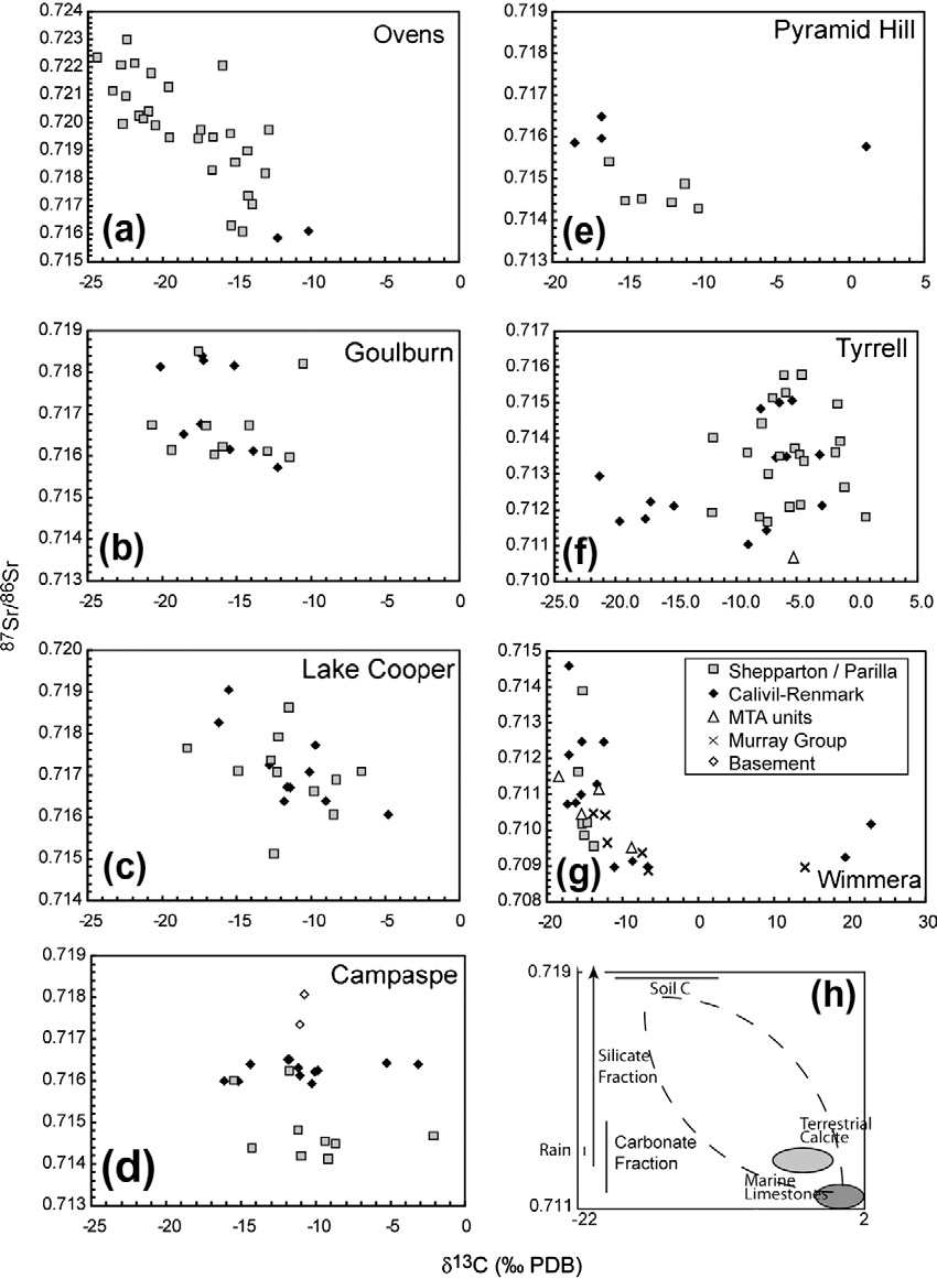
87Sr/86Sr ratios of the calcite throughout the Riverine Province re-flect that it is largely non-marine. The d13C values of calcite in most
1.2. Groundwater chemistry
aquifers are very variable, ranging between �17‰ and +2‰ which also reflects the largely non-marine nature of the calcite.
The processes controlling the major ion geochemistry are simi-
Only in the Wimmera region is the calcite dominantly marine. Cal-
lar throughout the southern Murray Basin and are described in de-
cite from the limestones of the Murray Group has d13C values of
�2.4‰ to +2.2‰ while Renmark Formation and Loxton–Parilla
Sands contain calcite with d13C values of �3.5‰ to �0.7‰ (
and The dominant hydrochemical
Groundwater from the various catchments has different
process is evapotranspiration of rainfall during recharge with min-
87Sr/86Sr ratios (Ovens: 0.716–0.723; Goulburn: 87Sr/86Sr = 0.716–
or silicate weathering and minor precipitation and/or dissolution
0.719; Campaspe: 0.714–0.719; Pyramid Hill: 0.714–0.716; Lake
of carbonate, gypsum, and halite. Cation exchange (especially the
Cooper: 87Sr/86Sr = 0.715–0.719; Tyrrell = 0.711–0.716; Wimmer-
sorption of Na onto clays and the release of Ca and Mg) modifies
a = 0.709–0.715: ). Aside from the Wimmera region,
the composition of the most saline groundwater. Many of the sili-
the Riverine Province aquifers are dominated by silicate minerals,
cate-dominated aquifers in the southern Murray Basin are rela-
thus carbonate weathering and/or mixing between groundwater
tively unreactive and water–rock interaction during groundwater
from carbonate and silicate aquifers are not likely to be a major
flow is limited; indeed processes in the unsaturated zone probably
processes. However, locally, carbonate cements and veins do exist.
control much of the groundwater geochemistry (
Given that carbonate minerals are generally more reactive than sil-
). Carbonate dissolution is locally important in controlling
icates, calcite dissolution may still control the 87Sr/86Sr ratios and
the geochemistry of groundwater in the Murray Group aquifer
d13C values of groundwater. For groundwater from most of the
); however, it is
catchments the lack of correlation between 87Sr/86Sr ratios and
only a minor process elsewhere. Given that evapotranspiration is
d13C values (suggests that there has not been significant car-
the dominant process, there in a broad inverse correlation between
bonate dissolution. This conclusion is difficult to make from the
the TDS concentration of groundwater and recharge rates (
isotope data alone as in some catchments the d13C values of calcite
are variable. In addition, methanogenesis has locally increased d13C
catchments containing saline groundwater have low-
values of DIC in the Campaspe, Wimmera, Pyramid Hill, and Tyrrell
er recharge rates than catchments containing lower salinity
). However, the following observations imply that
I. Cartwright et al. / Applied Geochemistry 27 (2012) 1698–1709
Fig. 3. Variation in 87Sr/86Sr ratios of Riverine Province groundwater with distance from the basin margins in the Ovens (a), Goulburn (b), Lake Cooper (c), Campaspe (d),Pyramid Hill (e), Tyrrell (f), and Wimmera (g) catchments (data from: ).
calcite dissolution is not a major process: (1) carbonate cements
change as a result of cation exchange on clays that are derived from
and veins are a minor component of the aquifers, especially in
weathering of (and which have the similar 87Sr/86Sr ratios to) the
the east of the province; (2) trends in Sr/Cl or Sr/Na vs. 87Sr/86Sr
primary silicate minerals ().
are not consistent with carbonate dissolution in most of the catch-
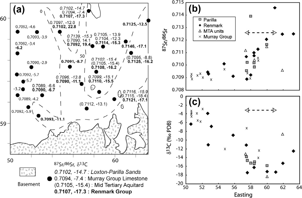
The variation of 87Sr/86Sr ratios and d13C values in the Wimmera
ments (and (3) as noted earlier, the major
groundwater reflects both inter-aquifer mixing and
ion geochemistry implies that carbonate dissolution is limited.
calcite dissolution. Calcite in the Renmark Formation and Loxton–
The 87Sr/86Sr ratios in the Ovens, Goulburn, Lake Cooper and
Parilla Sands in the Wimmera region has 87Sr/86Sr ratios 0.709–
Tyrell catchments in both the Shepparton and Calivil Renmark For-
0.713 and d13C = �3.5‰ to �0.7‰ (
mations broadly decrease with distance from the basin margins.
The variation in 87Sr/86Sr ratios and d13C
This spatial variation in 87Sr/86Sr ratios reflects variations in the
values in groundwater from the Loxton Parilla Sands and in the
distribution of minerals within the aquifers. Potassium-rich miner-
Renmark Formation where it is not overlain by the Murray Group
als, such as biotite and K-feldspar that generally have higher
results from the dissolution of calcite by groundwater that initially
87Sr/86Sr ratios are more abundant in the proximal parts of the
had high 87Sr/86Sr ratios and low d13C values. However, groundwa-
aquifers close to the basin margins, while more distal sediments
ter in the Renmark Formation where it underlies the Murray Group
contain higher relative abundances of plagioclase that has lower
has lower 87Sr/86Sr ratios than those of calcite in the Renmark
87Sr/86Sr ratios The major ion
Formation (implying that additional mixing of water from
chemistry (especially the low cation/Cl ratios) implies that pro-
the Murray Group has occurred. Mass balance calculations based
gressive silicate weathering during groundwater flow is only a
on the Sr and C isotopes and concentrations suggest that locally
minor process (Cation exchange (especially
up to 40–70% of the groundwater in the Renmark Formation was
the exchange of Na for Ca, Mg, and Sr) is well documented in
derived from the overlying Murray Group (
Murray Basin groundwater and the 87Sr/86Sr ratios probably
). In support of this assertion, groundwater from the Renmark
I. Cartwright et al. / Applied Geochemistry 27 (2012) 1698–1709
Fig. 4. 87Sr/86Sr ratios vs. d13C values of Riverine Province groundwater in the Ovens (a), Goulburn (b), Lake Cooper (c), Campaspe (d), Pyramid Hill (e), Tyrrell (f), andWimmera (g) catchments. (h) 87Sr/86Sr ratios of the aquifer matrix and predicted trends for carbonate dissolution (dashed lines) (data from ).
Formation where it underlies the Murray Group has Ca:HCO3 ratios
corrections are required for input of old 14C-free C from: (1) disso-
that are similar to those of groundwater from the Murray Group but
lution of carbonate minerals or organic material from the aquifer
dissimilar to those of groundwater from the Renmark Formation
matrix; (2) deep-seated geogenic CO2 from volcanic activity; and
elsewhere (). Similar calculations imply that
(3) CH4 generated via the breakdown of organic material in the
locally 80–95% mixing from the Loxton–Parilla Formation is re-
aquifer matrix. There are numerous schemes for correcting 14C
quired to explain the Murray Group groundwater with high
ages based on d13C values of DIC (e.g.,
87Sr/86Sr ratios and low d13C values
). Comparable estimates of upward leakage between the Ren-
). Most of these schemes assume that DIC
mark Formation and the Murray Group NW of the Wimmera region
in groundwater is derived largely from open-system dissolution
of 15–85% were made by .
of CO2 from the soil zone and that subsequent dissolution of (or ex-change with) carbonates in the aquifer matrix is the main processthat impacts d13C values and a14C in the aquifers.
4. Distribution of 14C ages
Despite most aquifers in the Riverine Province of the Murray
Basin being dominated by silicate minerals and the input of geogen-
summarise the distribution of 14C ages in the Riv-
ic CO2 not being likely, the correction of a14C in Murray Basin
erine Province. While 14C is the most commonly used tracer to
groundwater is not straightforward. In some catchments, such as
determine groundwater residence times in regional aquifers, its
the Campaspe, the d13C values of DIC range from �18‰ to +2‰
application is not without considerable problems. These include
(Using these d13C values to correct 14C ages assuming that
the anomalously high a14C activities in groundwater recharged
dissolution of matrix calcite had occurred implies that locally
since the 1950s due to the atmospheric nuclear tests. Additionally,
>90% of the DIC is derived from calcite dissolution. However,
I. Cartwright et al. / Applied Geochemistry 27 (2012) 1698–1709
Fig. 5. (a) Distribution of groundwater 87Sr/86Sr ratios and d13C values in the Wimmera region, dashed lines show extent and thickness (m) of Geera Clay. (b) Variation of87Sr/86Sr ratios from east to west across the Wimmera region. (c) Variation of d13C values from east to west across the Wimmera region. Dashed arrows indicate where theGeera Clay is thickest. From : ).
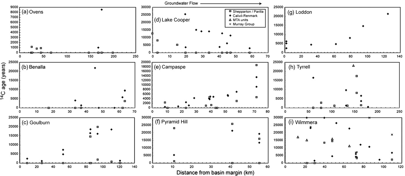
Fig. 6. Variation in 14C ages of Riverine Province groundwater with distance from the basin margins in the Ovens (a), Benalla (b), Goulburn (c), Lake Cooper (d), Campaspe (e),Pyramid Hill (f), Loddon (g), Tyrrell (h), and Wimmera (i) catchments (data from ).
87Sr/86Sr ratios and major ion geochemistry of groundwater imply
results in an increase in pH, and groundwater with d13C values
that calcite dissolution is only a minor process. DIC with high
>0‰ in both the Campaspe and Wimmera catchments have pH
d13C values is present in groundwater from other catchments
values >7.5 that are substantially higher than most of the other
(e.g., DIC from Wimmera groundwater has d13C values up to
samples; by contrast, acetate fermentation does not increase pH.
+14‰ while that from the Pyramid Hill and Tyrrell catchments
Secondly, acetate fermentation rarely produces DIC with d13C val-
has d13C values as high as +1‰). The variable and high d13C values
ues >0‰ ), whereas DIC reduction can produce
are most probably due to methanogenesis that occurs in the locally
d13C values in the range of those observed in the Wimmera and
anoxic conditions in these aquifers (
Campaspe groundwater (
). The following observa-
If methanogenesis has occurred, bacteriological reduction
tions support that methanogenesis is via the reduction of DIC in
of other oxidised species such as NO3 and SO4 is also likely. In the
groundwater rather than the breakdown of organic material from
Campaspe, Tyrrell, and Wimmera groundwater dissolved SO4 in
the aquifer matrix via acetate fermentation. Firstly, DIC reduction
the high d13C groundwater has d34S values of 25–50‰ a).
I. Cartwright et al. / Applied Geochemistry 27 (2012) 1698–1709
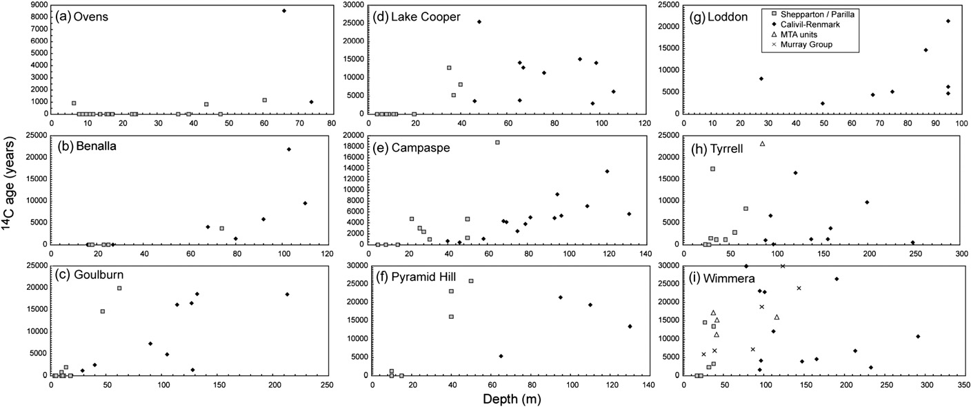
Fig. 7. Variation in 14C ages of Riverine Province groundwater with depth in the Ovens (a), Benalla (b), Goulburn (c), Lake Cooper (d), Campaspe (e), Pyramid Hill (f), Loddon(g), Tyrrell (h), and Wimmera (i) catchments (data from
Fig. 8. d34S values vs. d13C values (a) and S/Cl ratios (b) in groundwater from the Wimmera (Wim), Campaspe (Cam), and Tyrrell (Tyr) catchments. S concentrations areexpressed as ratios to Cl to remove the effects of variable salinity in the groundwater. Data from (
These values are much higher than those of gypsum in the local reg-
olith or playas (d34S = 15–24‰: ) and/or atmo-
were calculated using the statistical correction, with
spheric sources (d34S = 15–23‰: ) and
the exception of the Wimmera region where the corrected ages
reflects bacteriological SO4 reduction
based on d13C values are shown. Calculating ages in groundwater
The high d13C groundwater also has lower SO4
with low a14C is difficult due to analytical uncertainties and the
and NO3 concentrations (that are also consistent with bac-
possibility of contamination from the atmosphere during sam-
teriological reduction. Methanogenesis by this mechanism has only
pling; groundwater that has a14C <2 pMC is considered to be indis-
a minor impact on a14C. estimated that
tinguishable from background and is assigned an age of >30 ka.
the mass-dependant fractionation of 14C relative to 12C is �2.3 that
Groundwater with calculated a0 values that are >100 pMC contains
of 13C; thus, an increase in d13C of 10‰ should result in an increase
a component of water that was recharged during or following the
in a14C of only �2.3%.
atmospheric nuclear tests in the 1950s and 1960s (
In addition to methanogenesis, the d13C of calcite in the aquifer
While it is possible to use high 14C groundwater to constrain
matrix is not always well constrained and may be variable. This is
modern recharge processes for the
especially the case in the eastern part of the Riverine Province
purposes of this regional study this groundwater is considered to
where the sediments are largely non-marine. Given these uncer-
be modern with an effective age of 0 a.
tainties, a statistical correction which assumes that in silicate aqui-fers �15% of the C is derived from the aquifer matrix
4.1. Contrasting age distributions between catchments
has been applied. In the Wimmera and Goulburn catchmentswhere calcite in the silicate aquifers has a restricted range of
There is a distinct difference between the patterns of ground-
d13C values this statistical correction produces ages that are similar
water ages in the different catchments. Ages of the deeper
to those calculated using the d13C values
Calivil–Renmark Formation groundwater in the Goulburn, Loddon,
I. Cartwright et al. / Applied Geochemistry 27 (2012) 1698–1709
and Campaspe catchments increase with distance from the basinmargins (). Groundwater with residence times of 9–13.5 kais recorded �70 km from the basin margin in the Campaspe catch-ment, groundwater with residence times of up to 16.5–18.5 ka ispresent at 85–110 km in the Goulburn catchment, and groundwa-ter with ages of 21 ka is present at 125 km in the Loddon catch-ment. The age of groundwater from the Pyramid Hill Catchmentalso increases away from the basin margins (ages are up to 20 kabetween 40 and 55 km); however, this trend is defined by rela-tively few samples. One groundwater sample from the distal partof the Goulburn catchment yields an anomalously young age(�13 ka). This sample, which has higher NO3 concentrations anddifferent d18O values to adjacent groundwater (), is from the vicinity of a groundwater mound andmay be recording the mixing of recently recharged groundwaterwith deeper groundwater. Overall, the distribution of ages in thesecatchments implies a relatively simple pattern of lateral ground-water flow in the deeper Calivil–Renmark Formation with littlemixing from the overlying Shepparton Formation. Elsewhere,groundwater ages do not increase with distance from the basinmargins (). Indeed, in the Lake Cooper, Tyrell, and Wimmeracatchments the oldest groundwater from the Renmark Formationis commonly close to the basin margins. In none of the regionsdo the ages of Shepparton or Loxton–Parilla groundwater increasewith distance from the basin margins ); however in severalof the catchments there is an irregular increase in age with depth.
5. Oxygen and hydrogen isotopes
The d18O and d2H values of groundwater from all catchments
are similar and cluster around the global and Melbournemeteoric water lines at approximately the composition of modernprecipitation for Melbourne (d18O = �5.0‰, d2H = �28‰). Theoccurrence of samples to the left of the Melbourne meteoric waterline is probably due to climatic differences between Melbourne(which is coastal) and the Riverine Province (which is inland andmore arid). Groundwater with similar d18O and d2H values occurselsewhere in the Murray Basin The groundwater as a whole defines an array witha slope of �5 that is probably due to evaporation in a semi-aridenvironment ). However,most samples show an increase in d18O of <3‰ and there is no cor-relation of d18O values with TDS. A �5‰ increase in d18O values isproduced by �20% evaporation (which is far less than that required to produce the high
Fig. 9. (a) d18O vs. d2H values of Riverine Province groundwater by aquifer. Datacluster around the global (GMWL) and Melbourne (MMWL) meteoric water lines at
TDS contents of the Murray Basin groundwater. Thus transpiration,
about the value of modern rainfall in Melbourne. The arrowed line is a linear best fit
which does not significantly affect d18O values, is probably the
to the entire dataset and the inset shows changes in d18O vs. d2H resulting from
more important process in concentrating solutes in these waters.
various hydrological processes. (b) d18O vs. d2H values for Riverine Province
Prior to land clearing, the southern Murray Basin was dominated
groundwater from the different catchments. (c) d18O vs. 14C ages for RiverineProvince groundwater (data from
by native vegetation (particularly eucalypts) that was an efficient
user of available rainfall leading to significant transpiration
Despite groundwater recharge occurring in both high rainfall
areas (e.g. the Ovens catchment) and low rainfall inland areas
limited there is no change in the d18O and d2H values of groundwa-
(e.g. Tyrell and Wimmera catchments), there are no spatial varia-
ter along the catchment, and in no catchment is there a correlation
tions of d18O and d2H (b). Most recharge in the Murray Basin
between 14C age and d18O or d2H values (c).
occurs on the Riverine Plains that has limited topographical varia-tion and there is no altitude affect in the d18O and d2H data. Even inthe Ovens catchment, there are no major differences between thed18O and d2H values from groundwater in the more elevated upper
catchment and that in the lower catchment. As discussed above,groundwater in many of the catchments (particularly those that
Environmental isotope geochemistry has allowed an under-
are not deep leads) has undergone mixing that may have homoge-
standing of hydrogeochemical processes and regional groundwater
nised the d18O and d2H values. However, even in the Goulburn and
flow in the Riverine Province that was not possible from a consid-
Campaspe catchments where (as discussed below) mixing is more
eration of physical parameters and major ion chemistry alone.
I. Cartwright et al. / Applied Geochemistry 27 (2012) 1698–1709
6.1. Groundwater ages, salinity, and recharge rates
ing upwards mixing from the Calivil–Renmark Formation. A similardifference between 87Sr/86Sr ratios of the Calivil–Renmark ground-
Recharge in all catchments occurs across broad areas as the ba-
water and most of the groundwater in the Shepparton Formation is
sin is unconfined. In most of the Riverine Province, catchments
observed in the Pyramid Hill region ), which also precludes
outside the deep leads contain higher salinity groundwater with
significant inter-aquifer mixing in that area. In many of the other
older 14C ages while lower salinity groundwater from the deep
catchments, there is not sufficient distinction in the 87Sr/86Sr ratios
leads is relatively young. This inverse correlation is expected in ba-
to use these tracers to test whether mixing has occurred.
sins where the dominant hydrogeochemical process is evapotrans-
As discussed above, the increase in 14C ages with depth in the
piration. The coarser-grained sediments of the deep leads result in
Shepparton Formation and the Loxton–Parilla Sands indicates that
lower degrees of evapotranspiration and higher recharge rates, and
flow in these aquifers has a strong downward component. Down-
as a first approximation groundwater salinity is an indica-
ward flow in the shallow aquifers probably results from the much
tion of relative recharge rates. Recharge rates in the Shepparton
higher hydraulic conductivities of the deeper Calivil–Renmark For-
Formation may be calculated using the 14C data. Although the
mation compared with the near surface units that results in refrac-
trends of increasing age with depth are irregular in many of the
tion of groundwater flow paths. That significant mixing of this
catchments, groundwater with 14C ages of 15–25 ka commonly oc-
groundwater with the deeper groundwater is not observed in all
curs at �40–60 m depth (). The general trends of age with
catchments is probably a result of the relative hydraulic conductiv-
depth imply infiltration rates of approximately 1–4 mm/a with
ities. In the deep leads the high groundwater fluxes within the
higher rates in the deep leads than in the intermediate areas. For
higher hydraulic conductivity Calivil–Renmark Formation effec-
porosities of 0.2–0.3, these infiltration rates equate to recharge
tively dilutes the relatively minor leakage from the overlying units.
rates of 0.3–1.2 mm/a (�1% of modern rainfall). These are similar
The distribution of ages (allows estimation of hydraulic
to recharge rates estimated in the Murray Basin by Cl mass balance
parameters in the Campaspe, Goulburn, and Loddon catchments.
(0.03–2 mm/a: ). For an
The increase in groundwater ages in the Calivil–Renmark Forma-
average vertical hydraulic gradient of 0.05 and porosities of 0.2–
tion of 9–13.5 ka over �60 km in the Campaspe catchment implies
0.3, vertical hydraulic conductivities calculated using Darcy's Law
flow velocities of 4.4–6.7 m/a, which for a porosity of 0.2-0.3
are approximately 10�5 to 10�4. These are within the range of ver-
equates to a groundwater flux of 0.89–2.0 m3/m2/a. Lateral hydrau-
tical hydraulic conductivities for the Shepparton Formation of 10�5
lic gradients in the Murray Basin are typically 10�4 to 5 � 10�4 and
to 10�1 m/day reported by and
Darcy's Law yields lateral hydraulic conductivities of 4000–
8900 m/a (11–24 m/day). Similar calculations in the Loddon catch-
Groundwater from the Renmark Formation and Murray Group
ment assuming an increase in groundwater age of 21 ka over
in the west of the Riverine Province and in the adjacent Mallee
120 km yields hydraulic conductivities of 9–31 m/day, while
Limestone Province commonly has residence times of >30 ka (
assuming that the age increase in the Goulburn catchment is
Figs. 6 and 7), implying
18.5 ka over 80 km yields hydraulic conductivities of 7–25 m/day.
that recharge rates in this region are also low. By contrast with
These estimates are slightly below those estimated from pumping
groundwater elsewhere in the Riverine Province, this groundwater
tests in the deep leads (typically 40–200 m/day:
has low TDS contents implying that the low recharge rates are not
The difference may relate to
the result of extreme degrees of evapotranspiration. Rather, signif-
errors in the assumed hydraulic gradients; due to the increase in
icant recharge may occur mainly during infrequent higher-precip-
recharge rates following the land clearing over the past 200 a,
itation periods in this low rainfall region. If this is the case, rapid
the present-day hydraulic gradients may be higher than those that
recharge through the sandy soils that dominate this region may ac-
were typical in the southern Murray Basin over the length of time
count for the low salinity of the groundwater
that these flow systems have operated. Alternatively, as pump tests
record hydraulic conductivities over a relatively small region, theymay not be representative of the aquifer as a whole. Nevertheless,
6.2. Groundwater flow and inter-aquifer mixing
the broad agreement between the hydraulic conductivities calcu-lated from the 14C ages and those measured using pump tests im-
The increase in 14C ages with distance () implies that that
plies that the interpretation of groundwater ages and flow systems
groundwater flow in the Calivil–Renmark Formation in the deep
leads is relatively simple with little leakage from overlying units.
By contrast, the variation in 14C ages in the other regions implies
6.3. Variations with climate
that flow paths are complex and that there is considerable inter-aquifer mixing. This conclusion is supported by the distribution
Unlike large basins elsewhere (e.g.,
of TDS contents in groundwater. The highest salinity groundwater
in the Lake Cooper, Wimmera and Tyrrell catchments commonly
occurs close to the basin margins precluding simple lateral
groundwater flow, whereas TDS contents of Calivil–Renmark
is no correlation between 14C ages and d18O values in the Riverine
groundwater in the deep leads are relatively constant or increase
Province, and deeper groundwater has similar d18O values to shal-
along the flow paths. The variation of 87Sr/86Sr ratios in the Campa-
lower groundwater and to modern surface water and rainfall. The
spe catchment is also consistent with dominantly lateral
lack of variation in d18O and d2H values is surprising given that
groundwater flow in the Calivil–Renmark Formation with little
groundwater present in the basin was recharged over at least
vertical leakage. The 87Sr/86Sr ratios of the Calivil–Renmark
30 ka and that palaeoclimate studies show that between approxi-
groundwater within the Campaspe Valley are 0.7159–0.7165 while
mately 30–22 ka and 7–4 ka rainfall was higher than at present,
those of the Shepparton groundwater are 0.7141–0.7148 (If
while between �20 and 10 ka, conditions were considerably drier
inter-aquifer leakage were widespread, 87Sr/86Sr ratios in the Cali-
(). There is little evidence for these cli-
vil–Renmark groundwater should decrease along the flow path,
matic changes in the stable isotope data in the Riverine Province
which is not observed. The higher 87Sr/86Sr ratios of the Shepparton
groundwater, nor are there any obvious gaps in the 14C age spec-
groundwater at �75 km from the basin margin are probably pri-
trum that might result from extended periods of little recharge
mary as hydraulic gradients in this region are downwards preclud-
during periods of drier climate.
I. Cartwright et al. / Applied Geochemistry 27 (2012) 1698–1709
Rainfall in SE Australia derives from a variety of sources (mainly
laide), Geraldine Jacobsen (ANSTO), and Stuart Fallon (ANU) for
the Southern, Indian and Pacific Oceans) rather than dominantly
the 14C determinations. Marcus Onken and Kaye Hannam helped
from a single weather system ).
collect the samples. Ongoing funding by the Australian Research
While there are differences between the d18O values of rainfall de-
Council, the National Centre for Groundwater Research and Train-
rived from these systems (notably heavy winter rains from the
ing, and Monash University is gratefully acknowledged.
Southern Ocean have low d18O values) the variations in climatemay have been too slight to produce major differences in the over-
Appendix A. Supplementary data
all weather patterns (or at least in the resultant d18O values). Thisis in contrast to areas such as northern China that lie at the margins
Supplementary data associated with this article can be found, in
of the current monsoon systems where older groundwater has dis-
the online version, at
tinct d18O values due to variations in monsoon intensity (). Likewise, there
was not any dramatic change in hydrogeological conditions follow-ing glaciations, such as occurred in the higher latitudes of the
Allison, G.B., Colin-Kaczala, C., Filly, A., Fontes, J.C., 1987. Measurement of isotopic
northern hemisphere. Groundwater elsewhere in southern Victoria
equilibrium between water, water vapour and soil CO2 in arid zone soils. J.
also does not preserve a record of changing climate (
Hydrol. 95, 131–141.
Allison, G.B., Cook, P.G., Barnett, S.R., Walker, G.R., Jolly, I.D., Hughes, M.W., 1990.
). By contrast, low salinity groundwater from the
Land clearance and river salinisation in the western Murray Basin, Australia. J.
Mallee–Limestone Province of the Murray Basin was recharged
Hydrol. 119, 1–20.
dominantly at �20 ka (
Arad, A., Evans, R., 1987. The hydrogeology, hydrochemistry and environmental
isotopes of the Campaspe River aquifer system, North-Central Victoria,
), and related changes in salinity and
Australia. J. Hydrol. 95, 63–86.
d18O values along groundwater flow paths to climate variations.
Aravena, R., Wassenaar, L.I., Plummer, L.N., 1995. Estimating 14C groundwater ages
The recharge areas of the Mallee–Limestone Province are more arid
in a methanogenic aquifer. Water Resour. Res. 31, 2307–2317.
Brown, C.M., 1988. Overview of the Geology of the Murray Basin. Record – Bureau of
than those of the Riverine Province (current annual rainfall in the
Mineral Resources, Geology and Geophysics, 23–30.
Mallee–Limestone Province is �300 mm), and thus groundwater
Brown, C.M., 1989. Structural and stratigraphic framework of groundwater
recharge may be more sensitive to climate variations.
occurrence and surface discharge in the Murray Basin, southeastern Australia.
BMR J. Aust. Geol. Geophys. 11, 127–146.
Brown, C.M., Radke, B.M., 1989. Stratigraphy and sedimentology of mid-Tertiary
6.4. Resource implications
permeability barriers in the subsurface of the Murray Basin, southeasternAustralia. BMR J. Aust. Geol. Geophys. 11, 367–386.
Groundwater in the Riverine Province (especially in the Goul-
Bullen, T.D., Krabbenhoft, D.P., Kendall, C., 1996. Kinetic and mineralogic controls on
the evolution of groundwater chemistry and 87Sr/86Sr in a sandy silicate aquifer,
burn and Campaspe catchments) is locally used for irrigation, stock
northern Wisconsin, USA. Geochim. Cosmochim. Acta 60, 1807–1821.
watering, and increasingly for domestic supply. Population and
Bureau of Meteorology, 2010. Commonwealth of Australia Bureau of Meteorology.
economic activity in this region is increasing, as is the development
Calf, G.E., Ife, D., Tickell, S., Smith, L.W., 1986. Hydrogeology and isotope hydrology
of more intensive agriculture (e.g. orchards and vineyards). This in-
of upper Tertiary and Quaternary aquifers in northern Victoria. Aust. J. Earth Sci.
creased activity and the realisation that surface water provides an
33, 19–26.
unreliable supply in times of drought mean that groundwater will
Cartwright, I., 2010. Using groundwater geochemistry and environmental isotopes
to assess the correction of 14C ages in a silicate-dominated aquifer system. J.
be used increasingly for water supply. However, the results of
Hydrol. 382, 174–187.
these studies indicate that, in general, recharge rates are low and
Cartwright, I., Weaver, T., 2005. Hydrogeochemistry of the Goulburn Valley region
the groundwater is several thousands of years old; this water,
of the Murray Basin, Australia: implications for flow paths and resourcevulnerability. Hydrogeol. J. 13, 752–770.
therefore, constitutes a finite resource. Additionally, given the
Cartwright, I., Weaver, T.R., Fulton, S., Nichol, C., Reid, M., Cheng, X., 2004.
broad recharge areas, groundwater in the Shepparton Formation
Hydrogeochemical and isotopic constraints on the origins of dryland salinity,
and Loxton–Parilla Sands is susceptible to contamination from
Murray Basin, Victoria, Australia. Appl. Geochem. 19, 1233–1254.
agricultural activities, urban discharge, and the numerous small-
Cartwright, I., Weaver, T.R., Fifield, L.K., 2006. Cl/Br ratios and environmental
isotopes as indicators of recharge variability and groundwater flow: an example
scale industries scattered throughout the region. Secondary salini-
from the southeast Murray Basin, Australia. Chem. Geol. 231, 38–56.
sation (both dryland and irrigation) caused by rising water tables is
Cartwright, I., Hannam, K., Weaver, T.R., 2007a. Constraining flow paths of saline
affecting the shallow groundwater and the shallow saline water
groundwater at basin margins using hydrochemistry and environmentalisotopes; Lake Cooper, Murray Basin, Australia. J. Earth Sci. 54, 1103–1122.
produced by salinisation represents another potential threat to
Cartwright, I., Weaver, T., Petrides, B., 2007b. Controls on 87Sr/86Sr ratios of
the deeper groundwater. Where significant vertical groundwater
groundwater in silicate-dominated aquifers: SE Murray Basin, Australia. Chem.
flow into the Calivil–Renmark Formation occurs, the deeper
Geol. 246, 107–123.
Cartwright, I., Weaver, T.R., Stone, D., Reid, M., 2007c. Constraining modern and
groundwater too may be susceptible to contamination. Predicting
historical recharge from bore hydrographs, 3H, 14C, and chloride concentrations:
exactly where these impacts are most likely, however, is difficult
applications to dual-porosity aquifers in dryland salinity areas, Murray Basin,
because the heterogeneous nature of the Shepparton Formation re-
Australia. J. Hydrol. 332, 69–92.
Cartwright, I., Weaver, T.R., Tweed, S.O., 2008. Integrating physical hydrogeology,
sults in localised pathways of preferential flow. Vertical hydraulic
hydrochemistry, and environmental isotopes to constrain regional groundwater
gradients in the Riverine Province are increasing due to land clear-
flow: Southern Riverine Province, Murray Basin, Australia. In: Carrillo, R.J.J.,
ing and irrigation that have locally raised water tables by several
Ortega, G.M.A. (Eds.), International Association of Hydrogeologists SpecialPublication 11: Groundwater Flow Understanding from Local to Regional Scale.
metres increasing the potential for vertical flow. Excessive ground-
Taylor and Francis, London, pp. 105–134.
water extraction from the Calivil–Renmark Formation may also
Cartwright, I., Weaver, T., Cendón, D.I., Swane, I., 2010a. Environmental isotopes as
cause drawdown of saline or contaminated water through the pref-
indicators of inter-aquifer mixing, Wimmera region, Murray Basin, Southeast
erential pathways in the Shepparton Formation.
Australia. Chem. Geol. 277, 214–226.
Cartwright, I., Weaver, T.R., Simmons, C.T., Fifield, L.K., Lawrence, C.R., Chisari, R.,
Varley, S., 2010b. Physical hydrogeology and environmental isotopes to constrain
the age, origins, and stability of a low-salinity groundwater lens formed byperiodic river recharge: Murray Basin, Australia. J. Hydrol. 380, 203–221.
Celle-Jeanton, H., Huneau, F., Travi, Y., Edmunds, W.M., 2009. Twenty years of
We would like to thank the many colleagues that have assisted
groundwater evolution in the Triassic sandstone aquifer of Lorraine: impacts on
us over the years, including Marlen Yanni, Massimo Raveggi and
baseline water quality. Appl. Geochem. 24, 1198–1213.
Rachelle Pierson (Monash) for the stable isotope and anion analy-
Cendón, D.I., Ayora, C., Pueyo, J.J., Taberner, C., Blanc-Valleron, M.M., 2008. The
chemical and hydrological evolution of the Mulhouse potash basin (France): are
ses, Linda McMorrow (ANU) for the cation analyses, David Bruce
‘‘marine'' ancient evaporites always representative of synchronous seawater
(Adelaide) for the Sr isotope analyses, Fred Leaney (CSIRO, Ade-
chemistry? Chem. Geol. 252, 109–124.
I. Cartwright et al. / Applied Geochemistry 27 (2012) 1698–1709
Chiew, F.H.S., McMahon, T.A., O'Neill, I.C., 1992. Estimating groundwater recharge
Leaney, F.W., Herczeg, A.L., 1995. Regional recharge to a karst aquifer estimated
using an integrated surface and groundwater modelling approach. J. Hydrol.
from chemical and isotopic composition of diffuse and localised recharge, South
131, 151–186.
Australia. J. Hydrol. 164, 363–387.
Chivas, A.R., Andrews, A.S., Lyons, W.B., Bird, M.I., Donnelly, T.H., 1991. Isotopic
Leaney, F.W., Herczeg, A.L., 1999. The Origin of Fresh Ground Water in the
constraints on the origin of salts in Australian playas. 1. Sulphur. Palaeogeog.
Southwest Murray Basin and Its Potential for Salinisation. CSIRO Land and
Palaeoclimatol. Palaeoecol. 84, 309–332.
Water Technical Rep. 7/99.
Clark, I.D., Fritz, P., 1997. Environmental Isotopes in Hydrogeology. Lewis, New
Leaney, F.W., Herczeg, A.L., Walker, G.R., 2003. Salinization of a fresh palaeo-ground
water resource by enhanced recharge. Ground Water 41, 84–92.
Coetsiers, M., Walraevens, K., 2009. A new correction model for 14C ages in aquifers
Leybourne, M.I., Clark, I.D., Goodfellow, W.D., 2006. Stable isotope geochemistry of
with complex geochemistry – application to the Neogene Aquifer, Belgium.
ground and surface waters associated with undisturbed massive sulfide
Appl. Geochem. 24, 768–776.
deposits; constraints on origin of waters and water–rock reactions. Chem.
Currell, M.J., Cartwright, I., Bradley, D.C., Han, D., 2010. Recharge history and
Geol. 231, 300–325.
controls on groundwater quality in the Yuncheng Basin, north China. J. Hydrol.
Love, A.J., Herczeg, A.L., Armstrong, D., Stadter, F., Mazor, E., 1993. Groundwater
385, 216–229.
flow regime within the Gambier Embayment of the Otway Basin, Australia:
Darling, W.G., Edmunds, W.M., Smedley, P.L., 1997. Isotopic evidence for
evidence from hydraulics and hydrochemistry. J. Hydrol. 143, 297–338.
palaeowaters in the British Isles. Appl. Geochem. 12, 813–829.
Love, A.J., Herczeg, A.L., Leaney, F.W., Stadter, M.F., Dighton, J.C., Armstrong, D.,
de Caritat, P., Kirste, D., Carr, G., McCulloch, M., 2005. Groundwater in the Broken
1994. Groundwater residence time and palaeohydrology in the Otway Basin,
Hill region, Australia: recognising interaction with bedrock and mineralisation
South Australia: 2H, 18O and 14C data. J. Hydrol. 153, 157–187.
using S, Sr and Pb isotopes. Appl. Geochem. 20, 767–787.
Ma, J., Ding, Z., Edmunds, W.M., Gates, J.B., Huang, T., 2009. Limits to recharge of
Dogramaci, S.S., Herczeg, A.L., 2002. Strontium and carbon isotope constraints on
groundwater from Tibetan plateau to the Gobi desert, implications for water
carbonate–solution interactions and inter-aquifer mixing in groundwaters of
management in the mountain front. J. Hydrol. 364, 128–141.
the semi-arid Murray Basin, Australia. J. Hydrol. 262, 50–67.
Macumber, P., 1991. Interaction Between Groundwater and Surface Systems in
Dogramaci, S.S., Herczeg, A.L., Schiff, S.L., Bone, Y., 2001. Controls on d34S and d18O of
Northern Victoria. Victoria Department of Conservation and Environment.
dissolved sulfate in aquifers of the Murray Basin, Australia and their use as
Macumber, P.G., 1992. Hydrological processes in the Tyrrell Basin, southeastern
indicators of flow processes. Appl. Geochem. 16, 475–488.
Australia. Chem. Geol. 96, 1–18.
Edmunds, W.M., 2009. Geochemistry's vital contribution to solving water resource
Macumber, P.G., 2007. Aspects of the hydrogeology of the Mallee region. Proc. Roy.
problems. Appl. Geochem. 24, 1058–1073.
Soc. Victoria 118, 7–8.
Edmunds, W.M., Ma, J., Aeschbach-Hertig, W., Kipfer, R., Darbyshire, D.P.F., 2006.
Negrel, P., Petelet-Giraud, E., 2005. Strontium isotopes as tracers of groundwater-
Groundwater recharge history and hydrogeochemical evolution in the Minqin
induced floods: the Somme case study (France). J. Hydrol. 305, 99–119.
Basin, North West China. Appl. Geochem. 21, 2148–2170.
Négrel, P., Casanova, J., Aranyossy, J.-F., 2001. Strontium isotope systematics used to
Evans, W.R., Kellett, J.R., 1988. Overview of the hydrogeology of the Murray Basin.
decipher the origin of groundwaters sampled from granitoids: the Vienne Case
Record – Bureau of Mineral Resources. Geol. Geophys., 65–69.
(France). Chem. Geol. 177, 287–308.
Evans, W.R., Kellett, J.R., 1989. The hydrogeology of the Murray Basin, southeastern
Petrides, B., Cartwright, I., 2006. The hydrogeology and hydrogeochemistry of the
Australia. BMR J. Aust. Geol. Geophys. 11, 147–166.
Barwon Downs Graben aquifer, southwestern Victoria, Australia. Hydrogeol. J.
Fontes, J.C., Garnier, J.M., 1979. Determination of the initial 14C activity of the total
14, 809–826.
dissolved carbon; a review of the existing models and a new approach. Water
Petrides, B., Cartwright, I., Weaver, T., 2006. The evolution of groundwater in the
Resour. Res. 15, 399–413.
Tyrrell catchment, south-central Murray Basin, Victoria, Australia. Hydrogeol. J.
Galego Fernandes, P., Carreira, P.M., 2008. Isotopic evidence of aquifer recharge
14, 1522–1543.
during the last ice age in Portugal. J. Hydrol. 361, 291–308.
Rosenthal, E., Adar, E., Issar, A.S., Batelaan, O., 1990. Definition of groundwater flow
Gates, J.B., Edmunds, W.M., Darling, W.G., Ma, J., Pang, Z., Young, A.A., 2008.
patterns by environmental tracers in the multiple aquifer system of southern
Conceptual model of recharge to southeastern Badain Jaran Desert groundwater
Arava Valley, Israel. J. Hydrol. 117, 339–368.
and lakes from environmental tracers. Appl. Geochem. 23, 3519–3534.
Rozanski, K., 1985. Deuterium and oxygen-18 in European groundwaters – links to
Gonfiantini, R., 1986. Environmental Isotopes in Lake Studies. Elsevier, Amsterdam,
atmospheric circulation in the past. Chem. Geol.: Isotope Geosci. 52, 349–363.
Netherlands, pp. 113–168.
Saliege, J.F., Fontes, J.C., 1984. Essai de determination experimentale du
Herczeg, A.L., Barnes, C.J., Macumber, P.G., Olley, J.M., 1992. A stable isotope
fractionnement des isotopes 13C et 14C du carbone au cours de processus
investigation of groundwater–surface water interactions at Lake Tyrrell,
naturels. Int. J. Appl. Radiat. Isotopes 35, 55–62.
Victoria, Australia. Chem. Geol. 96, 19–32.
Sayed, S.A.S., Saeedy, H.S., Székely, F., 1992. Hydraulic parameters of a multilayered
Herczeg, A.L., Leaney, F.W.J., Stadler, M.F., Allan, G.L., Fifield, L.K., 1997. Chemical
aquifer system in Kuwait City. J. Hydrol. 130, 49–70.
and isotopic indicators of point-source recharge to a karst aquifer, South
Swane, I.P., Weaver, T.R., Lawrence, C.R., Cartwright, I., 2001. Hydrologic controls on
Australia. J. Hydrol. 192, 271–299.
groundwater salinisation, Murray Basin, Australia. In: Cidu, R. (Ed.), Proceedings
Herczeg, A.L., Dogramaci, S.S., Leaney, F.W., 2001. Origin of dissolved salts in a large,
of 10th International Symposium on Water–Rock Interaction. Balkema, Lisse,
Freshwater Resources 52, 41–52.
Tantawi, M.A., El-Sayed, E., Awad, M.A., 1998. Hydrochemical and stable isotope
Ivkovic, K.M., Watkins, K.L., Cresswell, R.G., Bauld, J., 1998. A Groundwater Quality
study of groundwater in the Saint Catherine-Wadi Feiran area, south Sinai,
Assessment of the Upper Shepparton Formation Aquifers: Cobram Region,
Egypt. J. Afr. Earth Sci. 26, 277–284.
Victoria. Australian Geolical Survey Organisation, Record 1998/16.
Tickell, S.J., 1978. Geology and Hydrogeology of the Eastern Part of the Riverine
Plain in Victoria, Melbourne. Geological Survey of Victoria Report 1977–8.
hydrogeochemical processes and the development of dryland salinity in the
Yass River Catchment, New South Wales, Australia. Hydrogeol. J. 5, 71–88.
Tickell, S.J., 1991. Shepparton Geological Report, Melbourne. Geological Survey of
Kalin, R.M., 2000. Radiocarbon dating of groundwater systems. In: Cook, P., Herczeg,
Victoria Report 88. Melbourne, Australia.
P. (Eds.), Environmental Tracers in Subsurface Hydrology. Kluwer, New York, pp.
Tickell, S.J., Humphries, J., 1986. Groundwater Resources and Associated Salinity
Problems of the Victoria Part of the Riverine Plain. Department Industry and
Katz, B.G., Bullen, T.D., 1996. The combined use of 87Sr/86Sr and carbon and water
Technical Research Victoria, Melbourne, Australia.
isotopes to study the hydrochemical interaction between groundwater and
Ullman, W.J., Collerson, K.D., 1994. The Sr-isotope record of late Quaternary
lakewater in mantled karst. Geochim. Cosmochim. Acta 60, 5075–5087.
hydrologic change around Lake Frome, South Australia. Aust. J. Earth Sci. 41, 37–
Lamontagne, S., Leaney, F.W., Herczeg, A.L., 2005. Groundwater–surface water
interactions in a large semi-arid floodplain; implications for salinity
Valentine, D.L., Chidthaisong, A., Rice, A., Reeburgh, W.S., Tyler, S.C., 2004. Carbon
management. Hydrol. Process. 19, 3063–3080.
and hydrogen isotope fractionation by moderately thermophilic methanogens.
Lawrence, C.R., 1988. Murray Basin. In: Douglas, J.G., Ferguson, J.A. (Eds.), Geology of
Geochim. Cosmochim. Acta 68, 1571–1590.
Victoria. Geological Society of Australia (Victoria Division), Melbourne, pp. 352–
Vogel, J.C., 1971. Groningen radiocarbon dates IX. Radiocarbon 12, 444–771.
Wasson, R.J., Donnelly, T.H., 1991. Palaeoclimatic Reconstructions for the Last
Le Gal La Salle, C., Marlin, C., Leduc, C., Taupin, J.D., Massault, M., Favreau, G., 2001.
30,000 years in Australia. A Contribution to Prediction of Future Climate. CSIRO
Renewal rate estimation of groundwater based on radioactive tracers (3H, 14C)
Division of Water Reources Techical, Report, 91/3.
in an unconfined aquifer in a semi-arid area, Iullemeden Basin, Niger. J. Hydrol.
Weaver, T.R., Frape, S.K., Cherry, J.A., 1995. Recent cross-formational fluid flow and
254, 145–156.
mixing in the shallow Michigan Basin. Geol. Soc. Am. Bull. 107, 697–707.
Leaney, F.W., Allison, G.B., 1986. Carbon-14 and stable isotope data for an area in
the Murray Basin: its use in estimating recharge. J. Hydrol. 88, 129–145.
Source: https://research.jcu.edu.au/tropwater/publications/Cartwrightetal2012ConstraininggroundwaterowresidencetimesinteraquifermixingandaquiferpropertiesusingenvironmentalisotopesinthesoutheastMurrayBasinAustralia.pdf
Notice acoustique – Phase DCE Construction d'un espace de loisirs SAINTE-GEMMES-SUR-LOIRE (49) Identification client Commune de Sainte-Gemmes-sur-Loire XP/10-215/BMN Nombre de page(s) 13/06/12 Maxime THEPAUT Mises à jour avec propositions d'économies 12/03/12 Maxime THEPAUT Société d'Etudes et de Réalisations pour la Diminution du Bruit Parc des Grésillières – 5 avenue Jules Verne – 44230 Saint-Sébastien-sur-Loire Tél. 02 40 34 11 22 – Fax 02 40 34 01 02 – [email protected] – www.serdb.com Société Anonyme Simplifiée au capital de 100 000 euros RCS NANTES B 390 839 454 – Code NAF : 7112B – N° TVA intracommunautaire : FR 28-390-839-454
Contents lists available at A critical role of follicle-stimulating hormone (Fsh) in mediating the effect of clotrimazole on testicular steroidogenesis in adult zebrafish Damien Baudiffier , Nathalie Hinfray , Mélanie Vosges , Nicolas Creusot , Edith Chadili , Jean-Marc Porcher , Rüdiger W. Schulz , Franc¸ois Brion a Institut National de l'environnement industriel et des risques (INERIS), Direction des Risques Chroniques, Unité d'écotoxicologie in vitro et in vivo, BP 2, 60550 Verneuil-en-Halatte,